


Marine Navigation - Lake Depth Maps - USA - Offline Gps Nautical Charts for Fishing, Sailing and Boating app for iPhone and iPad
Developer: Bist LLC
First release : 11 Feb 2013
App size: 42.77 Mb
Marine Navigation App offers access to NOAA marine vector charts, freshwater lake maps, USACE inland river maps. Only marine GPS app to have route assistance with Voice Prompts for marine navigation. It has route manager to create new boating routes or import existing GPX/KML routes. It supports Nautical Charts course up orientation. Includes Tide & Currents prediction.
* Hardware/GPU accelarated vector charts (text stays upright on rotation).
* Voice Prompts for marine navigation (requires GPS )
* 1ft / 3ft depth contour maps for anglers for selected lake maps.
* Supports GPX/KML for boating route editing/import.
* Tide & Currents prediction.
* Seamless chart quilting of marine charts
* Enter way points
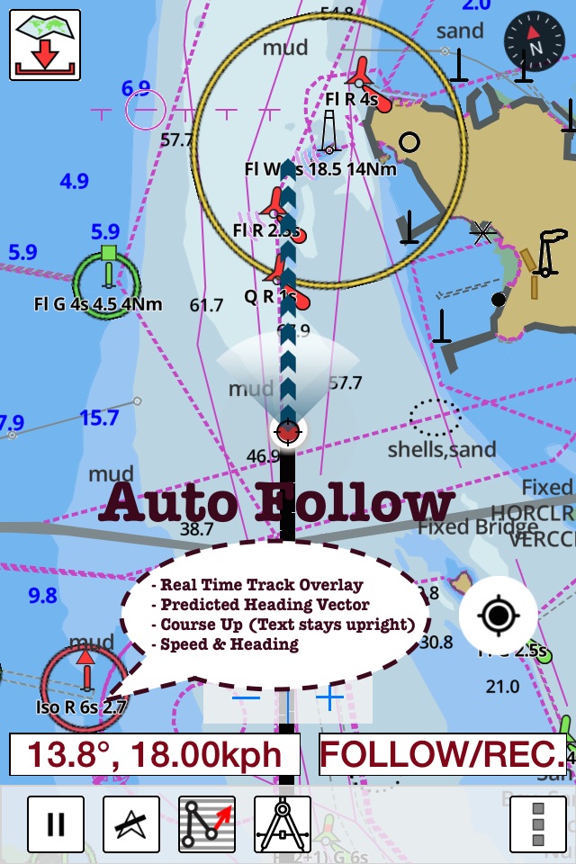
* Record tracks, Autofollow with realtime track overlay
* Voice Prompts for marine navigation (requires GPS )
-prompts when approaching a boating route marker
-Continous distance and ETA updates
-Alerts when sailing/boating off route
-Alerts when boating in wrong direction
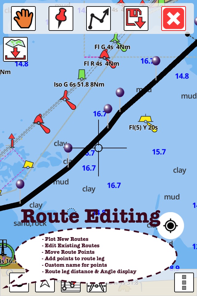
*Route Editing/Creation
-Create routes from scratch
-Edit existing GPX/KML routes.
-Add custom description to any route point.
-Drop markers along route.
* Offline NOAA marine, lake & river charts
-Visually download using grid
-Textual search
* Tide & Currents
- High / Low tides.
- Tidal Currents.
- Active currents stations.
*Seamless chart quilting of marine charts
*Distance Bearing tool
*Create custom way points
- Using GPS
-Select point on map
-Manually enter latitude & longitude coordinates
*Pan/Zoom/My Location
* Record Marine GPS tracks
* View tracks overlay
* Live track animation
* Track analytics/stats
* Export GPX trcks.
-Export to SDCard
-Share GPX tracks with friends.
* Auto Follow Mode (Course up)
-Continuously updates boats location on chart
- Adjustable update frequency
Sample Nautical Charts (please visit http://gpsnauticalcharts.com/main/folio-catalog-nautical-charts-app for complete list)
SUGARLOAF KEY-KEY WEST
PORT RICHEY TAMPA BAY - CLEARWATER HBR
EAST BAY-WEST BAY FLORIDA
ST JOSEPH, ST ANDREW BAYS
INTRACOASTAL WATERWAY MATECUMBE-GRASSY KEY
CHESAPEAKE BAY CAPE CHARLES-NORFOLK HARBOR
ANCLOTE KEYS-CRYSTAL RIVER
ST JOSEPH SOUND
MIAMI HARBOR
Minnesota lakes - Kabetogama, Minnetonka, Waconia,Leech,Mille Lacs
Lake Keowee,Jocassee,Hartwell,Greenwood,Lake Murray
Mark Twain,Ozarks,Table Rock
Lake St. Clair
Lake Kentucky
KEY WEST-THE MISSISSIPPI RIVER
SAN PEDRO CHANNEL
LAKE MICHIGAN STONY LAKE-POINT BETSIE
APALACHICOLA BAY-CAPE SAN BLAS
EAST CAPE-MORMON KEY
CAPE HENLOPEN-INDIAN RIVER INLET
CHESAPEAKE BAY CAPE HENRY-THIMBLE SHOAL LIGHT
DULUTH-SUPERIOR HARBOR
MONHEGAN ISLAND-CAPE ELIZABETH
LAKE ONTARIO - CLAYTON-FALSE DUCKS ISL
Lake Winnipesaukee
SAN FRANCISCO ENTRANCE
MIAMI-MARATHON, FLORIDA BAY
CAPE MAY-FENWICK ISLAND
MISSISSIPPI RIVER-GALVESTON
CAPE CANAVERAL-KEY WEST
DELAWARE RIVER WILMINGTON-PHILADELPHIA
FLORIDA KEYS SOMBRERO KEY-SAND KEY
SAN PABLO BAY
RAINY LAKE BIG ISLAND MINN-OAKPOINT ISL ONT
INTRACOASTAL WATERWAY - BISCAYNE BAY
EVERGLADES NTL PARK - SHARK RVR-LOSTMANS RVR
MIAMI-MARATHON & FLORIDA BAY
BLACKBURN BAY
LAKE HURON
LAKE TAHOE
STRAITS OF MACKINAC
NORFOLK HARBOR & ELIZABETH RIVER
SAN DIEGO-SANTA ROSA ISLAND
DELAWARE BAY
CHOPTANK RIVER CAMBRIDGE-GREENSBORO
FORT LAUDERDALE PORT EVERGLADES
ST SIMONS SOUND-TOLOMATO RIVER
CHESAPEAKE DELAWARE CANAL
CAPE MENDOCINO
STRAIT OF JUAN DE FUCA ENTRANCE
PORT RICHEY CLEARWATER HBR
PAMPANO BEACH-HALLADALE FLORIDA
LAKE ERIE
LAKE MICHIGAN INCLUDING GREEN BAY
MAIMI-MARATHON and FLORIDA BAY
SANTA CATALINA ISLAND
APALACHICOLA BAY-LAKE WIMICO
Battery Disclaimer:
"Continued use of GPS running in the background can dramatically decrease battery life."
Latest reviews of Marine Navigation - Lake Depth Maps - USA - Offline Gps Nautical Charts for Fishing, Sailing and Boating app for iPhone and iPad
Great app. Using it right now on my travel down the Chesapeake. Has speed, depth and I can download tons of noaa charts without additional charge that are accessible offline. Also one thing I like is to place a waypoint when I anchor. In the night if I am worried I am drifting I check this app to see where my gps is versus the anchor. That is super useful in my book.
I was able to transfer all my existing routes from my PC route planning software to this. I am glad it did not loose the names of points i had so meticulously entered. Looking forward to using it this summer.
I like how easy it is to plot precise routes using this app. Finally an app that gets it right.
Perfect app with perfect precision.. Now I dont have to use those clunky devices this summer. Love it..
Astoundingly bad - fraudulent would be a better description. This is a beta version, and a very early one at that. The screenshots show a simulator - the actual app does not have the functionality shown or advertised. The instructions do not even exist - site says "coming soon". The existing reviews are bogus, clearly posted by the developer (look at the names). I cant believe this made it into the App Store.